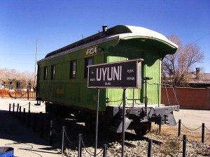
Quilt K – Potosi
[sphere 327]
Recommendations
Getting to know the entire environment is an unforgettable activity since it has unique landscapes in the world., However, being at a high altitude between 3600 until 5000 mt tall, far from cities , with limited services and difficult roads, It is necessary to consider the following recommendations.
Due to the type of places, they must carry the following:
– Protector solar
– Small cut banknotes
– Sleeping bag
– Personal first aid kit
– sunglasses
– Long trouses
– Long sleeve t-shirts
– warm clothing
– Gloves
– Flashlight
– Lip cream
– Hand and face cream
– wool hat
– Sun cap
– Chalina
– hiking boots
Use.- Take care of your backpacks and always be attentive to anything.
Altitude 4000 – 5000 masl
Temperatura mine. -10 C – Max. 20 C
[tabby title=”Description” open=”yes”]
Quilt K – Potosi
The main tourist attractions of the municipality are:
- Devil's Cave: The Devil's Cave, It has this name due to the stories of the residents about it.. It is said that at night sounds of music and voices are heard that are attributed to the presence of the devil.. Carnival festivities are held in this cave., It is customary to perform rituals and offerings to Pachamama by playing music.
- Calvary Virgin of Guadalupe: The Calvary of the Church of Colcha K, the Virgin of Guadalupe, It is located on a hill behind the town which, going up, allows you to observe the heights of the town and its surroundings.. The climb to Calvary is celebrated on 8 September when the entire population of the community goes up to the chapel and performs offerings and rituals to Pachamama asking for what each one needs through small representations of houses., land, plata.
- Church Quilt K: The Virgin of Guadalupe Church of Colcha K, It is located in the main square. It is in colonial style, renovated over time.
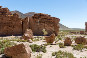
- Tanil Vinto Archaeological Cave and Museum: The Tanil Vinto Grotto presents in its wide spaces white rock formations that are believed to be petrified seaweed.. This cave does not have scientific studies, thus making its valorization and dissemination difficult.. The museum presents very old pieces of tableware, tissues and mummies found in the same area by residents.
- Community Quinoa Museum: The community quinoa museum has the most varied and complete collection of quinoa seeds, classified according to the diverse ecosystems of the Bolivian Altiplano region. Its exhibition teaches the preparation of the land for cultivation, the methods of harvesting and the various uses that are applied to this product both artisanally and in industries. The museum's infrastructure and furniture were built by the community's own inhabitants with local materials..
- Q`Atinchoo Archaeological Museum: The Atulcha museum is located inside a cave where mummies are exhibited (the chullpas) whole in its pieces, utensils of daily life of past civilizations, arrows of various sizes. Besides, In the vicinity of the museum there is a chullpa that, according to the stories of the population despite the characteristic looting of the region in the archaeological sites, it has never been possible to steal it. The reasons are not known but the population believes that this chullpa has some power, which is why people who have tried to steal it always return it to its place Atulcha.
- Atulcha craft workshop: The artisan workshop of the Atulcha community has recently been born, approximately the year 2006, where thanks to the support of cooperation, They have developed skills in making decorative objects out of queñua and cactus wood., typical of the area. It is a new livelihood for the community and its development.
- Cave paintings of Atulcha: The rock paintings of Atulcha are a witness to the ancient civilizations living in the area. The paintings represent zoomorphic figures.
- Manica Viewpoint: The Mañica viewpoint is located in the town center. It is a small hill where in past times rituals and customs were celebrated, Currently there are some remains of stones that were used as tables. The population of Mañica has made a path that allows you to go around the viewpoint. On one side you can see the town center and on the other, saline lands and surrounding hills.
- Legends and oral tradition: In the town of Mañica the link with the oldest civilizations is very strong, The population has memory of their ancestors through stories and legends that characterized the people and that over time are transmitted from generation to generation..
- Poterro Canyon: The Poterro canyon of Santiago de Agencha allows you to take a walk in the middle of virgin nature that is located near the town center. It is the old ravine of a river where there is currently no water, but vegetation of different types.
- Calvary viewpoint with cactus: The nail of the church of Santiago de Agencha serves as a viewpoint of the landscape. The ascent is characterized by the presence of columnar cacti that grow near the path.
- Aguaquiza Archaeological Museum: The archaeological museum of Aguaquiza has a variety of objects and utensils belonging to past civilizations. Among these are arrows of small and medium dimensions, objects for agricultural use, kitchen utensils.
- Cactus and queñua wood craft center: Handicrafts that the population of Aguaquiza produces are made of cactus wood and queñuas typical of the area.. Through training and training courses, the population has undertaken and developed wood carving techniques, building a possibility of alternative economic benefit..
- “Las Maravillas de Zepita” tourist complex: The “Las Maravillas de Zepita” tourist complex includes a chullpa cemetery in a cave with underground tombs, a viewpoint at the top of the cave and the galaxy grotto, The galaxy grotto has great scenic value due to the particular internal white formations., Some first studies say that it is petrified seaweed. It is an interesting complex of tourist attractions where the community of Aguaquiza has focused its efforts on the valorization of the site..
- Llavica cave paintings: The cave paintings are located in a ravine near the town center of Llavica, represent domestic animals (llamas or donkeys) in white and red. There are no scientific studies on the paintings. From the heights of the ravine you can see the town of Llavica and its surroundings.
- Inca Gate – Chaupin Pukara – Inca Corral Pata: The proposed circuit in the communities of Llavica and Villa Candelaria values nature and some archaeological remains that after 10 km. hiking trails are located at the top of a hill where you can see the surroundings. These remains preserved in good condition, They have the name of Puerta del Inca, Chaupin Punkara and Inca Corral Pata.
- Museo Wealth Wessy – Necropoliis: In the town center of San Juan del Rosario there is an archaeological museum that has an infrastructure where objects and belongings from past civilizations are exhibited with detailed historical and chronological explanations.. Part of the museum is an interpretation trail of an open-air necropolis with a multitude of oval-shaped tombs where mummies and utensils are found inside..
- Lakaya Archaeological Site: The Lakaya archaeological center, which in Quechua means “town in ruins,” is one of the most important pre-Columbian settlements in Lípez., name by which the Bolivian Altiplano south of the Salar de Uyuni is known, The site covers about 7 hectares distributed in two main sectors: a fortified redoubt on top and a town at its feet. It was inhabited between the 12th and 17th centuries AD.; a time marked by profound social and political changes, including the expansion and fall of the Inca Empire and the Spanish Conquest of America.
- Escocali: Escocali is a town center far from Santiago K where it is accessible on foot.. It presents a rocky landscape and typical vegetation. On the slope of some flat and smooth rocks there are cave paintings that, due to time and exposure to the elements, They are currently barely visible. However, The walk and the tour are interesting because of the nature and its surroundings.
- Ayarwakuna: Ayarwakuna is an archaeological site where remains of housing constructions or silos of human settlements previously present in that area are found.. Stone constructions located at the base of a large rock wall can be seen.. The local population thinks that these constructions served to punish people who left themselves isolated in that area..
- San Antonio Lagoon: Laguna San Antonio is a medium-sized lagoon located at the foot of a wall of high rocks.. It is a permanent lagoon where several species of birds live and surrounded by high slopes of smooth rock..
- Cave paintings and chullpas of Santa Barbara: The cave paintings and chullpas of Santa Bárbara are in good condition.. They are located in a small cave at the foot of a hill.. The cave paintings represent red flora of the place. Unfortunately there are no scientific studies and therefore it cannot be defined exactly with more certain data..
- Quebrada Pukara: The Pukara ravine, as defined by the name, is a pukara where homes or silos from past civilizations are recognized., located on the flat tops of high rocks that form a deep ravine. It has a slope, top-base approx. 100 m. It offers a beautiful spectacle enriched by the permanent river that runs at the base of the ravine..
- stone zoo: Near the town center of Villa Mar, There is a plain with a large number of rocks isolated from each other, among which there are formations that take the shapes of animals and objects. It is a place suitable for walks.
- City`s Villa Mar: “Llajtaq`aqa” name that indicates a stone town, according to the “ancients” of the town of Villa Mar. In the middle of a plain, large walls of smooth rock are erected, creating a peculiar landscape..
- Puka Pukara and cave paintings by Tomas Laq`A: The Puka Pukara is an archaeological site that preserves the urban structure and probably defensive walls of past civilizations in very good condition.. The cave paintings are located near the Puka Pukara. There are anthropomorphic and zoomorphic representations.
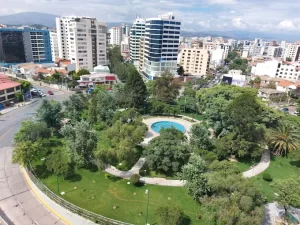
- San Cristóbal town center: The current town center of San Cristóbal is the “new” town that has been built due to the presence of the mining deposits that are currently being exploited through the San Cristóbal Mining Company.. In the past, the town of San Cristóbal was further away from what it is today.. The town center is a new urbanization that has many communication services, viability, public services.
- Irucancha Viewpoint: The Irucancha viewpoint is a natural viewpoint that is complemented by a wooden house made to better enjoy the landscape. 360 degrees. From this viewpoint you can see the open-air excavations of the San Cristóbal Mining Company on one side and on the other., the Salar de Uyuni can be seen in its extension, o Tunupa with its islands and its hills.
- Kulpina K village center: Culpina K or Kulpina K is a town that is part of the “model towns” in terms of reconstruction, it has sought to value cultural aspects such as the use of stones for constructions., The style and urban organization also use typical concepts of the area.
- Archaeological ruins of Laguna Vena: Impressive settlement of 7 ha. Extensive with dozens of large, almost cylindrical towers that today are completely empty but in a good state of conservation.. The towers have preserved their roof made of a forward vault. The natural unevenness between the hill and the surrounding esplanade, They have been used to install enclosures made of stone attached to the natural walls that must have served as living quarters.. The presence of water must have favored the agriculture of grasses and tubers. There is a shortage of ceramics and other materials on the surface. In chronological terms we can ascribe the site to the period of late regional development. (1100-1460 d. C.).
- Cerro Cuvincho: It is an isolated hill in the middle of a large plain that offers a beautiful landscape setting and the possibility of observing typical flora and fauna of the Altiplano..
- Pozo Cavado craft center: The Pozo Cavado Craft Center, produces clothing made of alpaca fiber, with natural and synthetic dyes. At the moment it does not have a very varied production of garments, It is quite limited due to lack of markets.
- Cruz Vinto. In Cruz Vinto, The houses are crowded on a plateau surrounded by rocky cliffs, that rises around 100 m above the surrounding terrain. The town can only be reached from the northwest and southwest ends of the plateau, which are protected by walls of 1 m thick, with three well-defined entrances and several openings similar to “embrasures”, from where the occupants of the site will be able to spot the enemy without exposing themselves to shooting with bows and arrows . Cruz Vinto has public spaces or squares, which are clearly recognizable due to the great density of the building.
- Kollije Viewpoint: The Kollije viewpoint is located 16 km from the town of Colcha K. It is a hill from which you can see the Salar de Uyuni, its islands, the Chilean territory and the Lípez mountain range. To reach and take advantage of this viewpoint, one day and good availability for hiking are required.. The community is interested in implementing a visit with a telescope that allows viewing the entire environment..
- San Cristobal Church: The Church, like the original town of San Cristóbal, It was moved stone by stone from its original location due to the mining deposit on which the town and the temple were located.. Through a difficult agreement reached between the population and the mining company interested in the area, was achieved with the support of experts, the integral transfer of the Church. The only details that have had to be replicated through specific studies and actions have been the internal paintings. The Church of San Cristóbal presents a baroque architecture typical of the 17th century.; It was built by the Jesuits. As on its original site, The Church is located within a large property fenced with perimeter walls, The south side is intended for the main entrance to the atrium and the Church, in the central part of which there is a lowered arch flanked by eight smaller arches and at the ends by two sober belfries accessible from the outside from a slight retreat from the street.. There is also a side entrance to the west of the plaza., towards a patio then to the nave. Cut stone pools covered with a vault stand out in the four corners within the perimeter walls.; There are two other pools in the town. This monument, with an original Latin cross plan, it presents a single nave, minor and major altar in the arms of the transept. Attached to the left side of the nave is the baptistery where you can see extremely interesting mural painting.. From this, access to the upper choir, There is also a mural painting in the nave where there is also an altar attached to the left side with lateral supports, The sacristy was later attached to the left side of the main altar., and to this a deposit. The roofs are made of gabled straw., the walls are wide, rammed earth, plastered with lime and stone foundation.
- Viacha craft center: The Association of Artisans of the Viacha Artisan Center produces clothing made of alpaca fiber, with natural and synthetic dyes. At the moment it does not have a very varied production of garments, It is quite limited due to lack of markets.
The altitude of the plateau greatly affects the atmospheric conditions: the air is rarefied and diaphanous, making insolation and irradiation high; humidity, low and heat diffusion, reduced. The temperature, with sun exposure, is high, while it's low in the shade.
The Municipality has an arid and cold climate. The thermal regime is characterized by an average annual temperature of about 9ºC., average maximum of 18ºC and average minimum of 1ºC. Precipitation is scarce, with an average annual value of 202 mm, and they occur from December to March, reaching maximum values in January. Evapotranspiration is very high, There is a humidity deficit throughout the year.. Frost occurs at any time, but with greater incidence in the months of May to August.
[tabby title=”+Places”]
[do_widget id=arpw-widget-12]
[tabby title=”+info PDF”]
[gview file=”https://boliviaesturismo.com/wp-content/uploads/2016/01/salar-de-uyuni.pdf” save=”0″]
[tabby title=”Tourism Companies”]
[do_widget id=arpw-widget-6]
[do_widget id=arpw-widget-13]
[do_widget id=rednao_smart_forms_widget-2]
[tabby end]