Saint Peter of Quemes – Potosi
[sphere 327]
Recommendations
Getting to know the entire environment is an unforgettable activity since it has unique landscapes in the world., However, being at a high altitude between 3600 until 5000 mt tall, far from cities , with limited services and difficult roads, It is necessary to consider the following recommendations.
Due to the type of places, they must carry the following:
– Protector solar
– Small cut banknotes
– Sleeping bag
– Personal first aid kit
– sunglasses
– Long trouses
– Long sleeve t-shirts
– warm clothing
– Gloves
– Flashlight
– Lip cream
– Hand and face cream
– wool hat
– Sun cap
– Chalina
– hiking boots
Use.- Take care of your backpacks and always be attentive to anything.
Altitude 4000 – 5000 masl
Temperatura mine. -10 C – Max. 20 C
[tabby title=”Description” open=”yes”]
Saint Peter of Quemes – Potosi
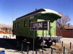
The town center of San Pedro de Quemes, is a municipality of Bolivia in the province of Nor Lípez of the Department of Potosí. You can reach the town through an unpaved road., from Uyuni (189 km).
Sloping terrain with a slight slope, with soft sinuous undulations in its lower part it becomes almost flat. It is located at 3,690 masl.
The main economic activity is agriculture and camelid breeding. (llamas). As a secondary activity they deal with tourism, there are some simple hostels.
The quality of the homes in San Pedro de Quemes is average. Most of its houses are built of adobe and have a distribution of rooms with regular functionality., having a patio in the central part. The bathroom and kitchen are generally outside the housing module.. Construction materials used in common homes, In order of greatest use they are: Foundations and coverings are made of stone and mud, with a low percentage of cyclopean concrete and dry masonry, Their roofs are made of corrugated iron and a few are made of straw., It has interior earthen plasters and a low percentage of plaster, the exterior plaster with mud and lime/cement. In the lodgings the buildings are made of stone and/or brick. Calamine and straw covers. Interior plastering with plaster and cement. Exterior plaster with mud and lime/cement.
The main tourist attractions of the town and surroundings are:
Burned Town: In 1879, in the Pacific War, The Chilean military invaded Bolivia, entering through what today are the Pajancha and Kana cantons (Oh Cana) of the municipality of San Pedro de Quemes. Arriving at the town of San Pedro, the military burned all the houses, causing the population that survived the tragedy to move to a corner of the municipality., in what is called Ikala today (ó Case). After several years, due to lack of water in Ikala, The population decided to return to the town of San Pedro to rebuild homes, At that time they decided to change the name of the town to San Pedro de Quemes, located on the same slope as the old town.
I'm gone: The town of Ikala is currently uninhabited. Here the survivors of the Chilean military incursion in 1879. Currently a church is preserved in the town of Ikala. Located from Ikala 7 km from San Pedro de Quemes.
Kuntur monkey: It is a ravine in which you can hike. The name, in quechua, It tells us that in the past there were presence of condors (vulture), but currently (2010) it is difficult to spot. Kuntur Kuntur is situated to the 8 km from San Pedro de Quemes.
chulpas tuk’uta: The chulpas are located at the top of a hill that offers a panoramic view of the town center of San Pedro de Quemes and its saline lands.. The chulpas are in good condition.. The chulpas are 14.6 km from San Pedro de Quemes.
Rock paintings and petroglyphs of Jawincha: The cave paintings of Jawincha (from Jaguincha) They are located on the walls of a plateau near the station of the same name., a 22 km from San Pedro de Quemes. The paintings depict stylized men and animals. There are also, figures engraved in the rock, whose meaning has not yet been deciphered.
Cave paintings of Hunohuaic’o: The Hunohuaic'o cave paintings are located on the walls of a plateau near the ranch of the same name., a 22 km from San Pedro de Quemes. The paintings represent three large stylized men (1.40 m).
chulpas planning: The Planchita chulpas are a group of small old stone houses, which have the characteristic of being lower with respect to ground level. You can see small corridors between the houses. The height at which the chulpas or fort are located allows you to observe the surroundings of the salt flat and other hills.
Pelcoya town center: It is located at 40 km from San Pedro de Quemes. It is a typical small town, located on the side of a hill. The houses are made of adobe with thatched roofs.. The square preserves a traditional church in colonial style. The square is decorated with kiswaeras plants.
Holy Cave: It is located in a ravine near the Pelcoya town center.. The ravine has a small river and crops on its slopes. The name is due to a painting found on one of the walls on the slopes of the ravine and represents a cross and a chalice in yellow and red, respectively..
Ladislao Cabrera River town center: Cabrera is a small town where two families live. close to homes, where there is also accommodation there is a trout farm. Various lithic objects such as arrows and cutters have been found in the area.. It is located at 33 km from San Pedro de Quemes.
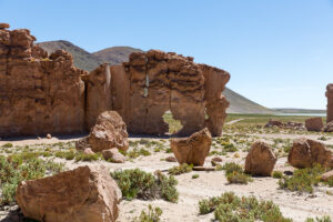
Rocks Soldiers: The name is due to the shape of the rocks of volcanic origin, found in a vast area, all in the same position. It is located at 10.5 km from San Pedro de Quemes.
Four Lagoons: Cañapa Cañapa, Hideous, Honda, Ramadita: The four lagoons of the Pelcoya canton present a spectacular landscape enriched with a rich fauna present in the area.. Among others, flamingos have been observed, one of the genus Phoenicopterus and two of the genus Phoenicoparrus, suris (Pterocnemia pennata), various species of ducks and foxes ( Pseudalopex culpaeus). The lagoons are located between 4,118 y 4,142 masl. To get there you pass through Avaroa, las 4 lagoons are approximately 148 km from San Pedro de Quemes.
Irruputuncu Volcano: It is a volcano of the category “stratovolcanic”, that is, composed of multiple layers of hardened lava, pyroclast and volcanic ash. These volcanoes are characterized by a steep profile and periodic, explosive eruptions.. The lava that flows from its interior is highly viscous, It cools and hardens before it can get far. The magma source of this mountain is classified as acidic, or high in silicon, with presence of rhyolite, dacite and andesite. It is currently an active volcano. Presents fumaroles with high sulfur content, which is perceived by the strong smell that emanates. Access: Starting from San Pedro de Quemes, we travel through 54 km to the Milestone 60. From the Milestone 60 to the volcano they are 20 km.
Chigua and Chaca ravine: They are two plateaus of about 35 m high above the surrounding terrain. Good place for walks, located at 67 km from San Pedro de Quemes.
Olca Volcano hot springs: The hot springs of the Olca Volcano are large pools of hot water with approximately 1 – 1.5 m depth. They are located near the road on a wide plain of grasslands and saline lands..
hot pot: Pocito Caliente, as the name says, is a pool of hot water where you can bathe.. It is a natural pool without infrastructure between tholares.
Pajancha town center: The Pajancha town center is a small town that preserves typical houses and structures (adobe and straw). Currently the phenomenon of migration is very strong but some families are working to revalue the town through tourism and the potential that exists in the area such as the amount of wild flora and fauna that circulates in the area so much that they want to promote the creation of a nature reserve area..
Empexa Hot Springs: The Empexa hot springs are part of the “Natural Sites” category., “Underground Waters”. They are hot springs with abundant hot water. The pool is located in the river ravine, so it is naturally protected. The site is totally isolated and immersed in nature.
[tabby title=”+Places”]
[do_widget id=arpw-widget-12]
[tabby title=”+info PDF”]
[gview file=”https://boliviaesturismo.com/wp-content/uploads/2016/01/salar-de-uyuni.pdf” save=”0″]
[tabby title=”Tourism Companies”]
[do_widget id=arpw-widget-6]
[do_widget id=arpw-widget-13]
[do_widget id=rednao_smart_forms_widget-2]
[tabby end]