Menu – Potosi
[sphere 327]
Recommendations
Getting to know the entire environment is an unforgettable activity since it has unique landscapes in the world., However, being at a high altitude between 3600 until 5000 mt tall, far from cities , with limited services and difficult roads, It is necessary to consider the following recommendations.
Due to the type of places, they must carry the following:
– Protector solar
– Small cut banknotes
– Sleeping bag
– Personal first aid kit
– sunglasses
– Long trouses
– Long sleeve t-shirts
– warm clothing
– Gloves
– Flashlight
– Lip cream
– Hand and face cream
– wool hat
– Sun cap
– Chalina
– hiking boots
Use.- Take care of your backpacks and always be attentive to anything.
Altitude 4000 – 5000 masl
Temperatura mine. -10 C – Max. 20 C
[tabby title=”Description” open=”yes”]
Menu – Potosi
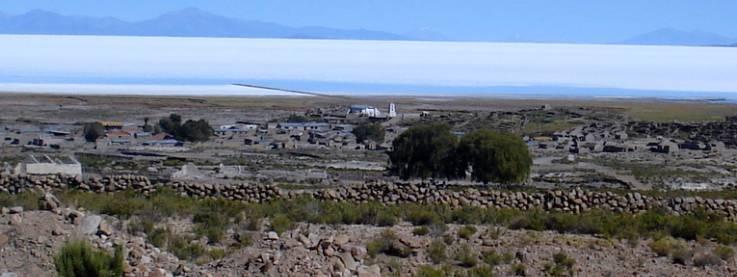
Tahua is a town and municipality in southwestern Bolivia., located in the province of Daniel Campos, in the department of Potosí. It is located approximately 200 km west of the departmental capital, the city of Potosí and 120 km from Uyuni through the Salar of the same name.
Sloping terrain with a slight slope, with soft sinuous waves. On one side of the town, An ephemeral river passes and in the sectors outside the town the terrain is rugged, having mountain ranges with steep slopes in the Southeast sector. It is located at 3,707 masl.
The altitude of the plateau greatly affects the atmospheric conditions: the air is rarefied and diaphanous, making insolation and irradiation high; humidity, low and heat diffusion, reduced. The temperature, with sun exposure, is high, while it's low in the shade. The community has an arid and cold climate. The thermal regime is characterized by an average annual temperature of about 8.5ºC., average maximum of 18ºC and average minimum of 1ºC. Precipitation is scarce, with an average annual value of 191 mm, and they occur from December to March, reaching maximum values in January. Evapotranspiration is very high, There is a humidity deficit throughout the year.. Frost occurs at any time, but with greater incidence in the months of May to August.
The main economic activity is agriculture and camelid breeding. (llamas). As a secondary activity they deal with tourism, there are some simple hostels. Many families have migrated, leaving their houses unoccupied. It is possible that a part of these families, to improve living conditions and employment possibilities, come back.
The quality of homes in Tahua is average. Most of its houses are built of adobe and have a distribution of rooms with regular functionality., having a patio in the central part. The bathroom and kitchen are generally outside the housing module.. The construction materials in order of frequency of use are: Foundations and coverings are made of stone and mud, with a low percentage of cyclopean concrete and dry masonry. Adobe and/or brick walls. Calamine covers, tile and straw. Interior plastering with plaster and mud. Exterior plaster with mud and lime/cement. There are interior and exterior paints in few cases. Cement and earth floors.
The main tourist attractions of the town and surroundings are:
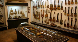
Chantani Museum: The museum is divided into two sectors, one dedicated to the exhibition of ancient and more recent materials such as tableware, utensils for kitchen and everyday life, garments, tools for working the land, old and more recent kitchens. A second sector where figures of animals made of stone and exposed in the open air are exhibited.. The site is presented as an inanimate zoo, ideal place for children.
Tahua Church: Church located on the banks of the Salar. It is interesting for its location and its large square. The Church of Tahua maintains its original style, church from the Colonial era. In the years 90 The bell tower has been rebuilt following the original style, It is currently in good condition.
Coqueza Mummies: The Mummies of Coqueza are located in a grotto offering an authentic appearance of the human fossils and other objects that are exhibited as archaeological heritage. (tableware, everyday utensils). During the ascent to the viewpoint and observatory, species of flora typical of the area have been recorded., pajonales, tolars.
Tunupa Volcano Observatory and Astronomical Observatory: The area where the viewpoint and the astronomical observatory are located is on the slopes of the Volcano, offering a look towards the Salar and its islands, and on the other hand towards the tops of the hill. The observatory is activated at night, It is an activity that the Coqueza community has complemented the tourist route. In the ascent of the Tunupa Volcano there are different ecological floors that in the flora species are characterized by tholares, grasslands and cacti that are located between the 3600 y 4700 masl. The fauna species are identified, bird species such as condors and eagles. 4700 y 5000 masl.. The viewpoint and the observatory allow the path that goes up to the Tunupa Volcano to be articulated., offering the possibility of taking photographs, walks suitable for all ages, rest and picnic areas. The observatory allows you to observe through a telescope, the constellations and the stars. The ascent of the Tunupa Volcano, offers the possibility of observing the Salar from its heights, its natural environment and the different ecological floors.
Pray of Page: The Nayra Pukara presents a set of pukaras and remains of human fossils and tableware belonging to ancient civilizations, Tiaawan (there is no more specific information). Thanks to the location and its altitude, you can see the view of the Salar, and its islands.
Inca Trail: The Inca Trail crosses the hills, from the community of Tahua to the community of Chillguilla, allowing you to walk between the hills, which are characterized by their flora, in particular cacti species and the view towards the Salar. The name of the trail is due to the Inca remains that can be seen, Along the path you can see remains of steps and walls built with stones that delimit the path. The most characteristic flora species in the area are cacti..
Call Mark: It is a fortified residential site, belonging to the Killacas civilization that ruled between the years 1200 -1450 d. C. It has abundant stone structures of ovoid or circular plants that served as silos or deposits for different types of food.. Thanks to the height of the Pukara's location, You can see the view of the Tunupa Volcano and its islands. As flora in the area, cacti species have been recorded that characterize the Pukara hills..
Chiquini Cave: Chiquini Cave is a cave with interesting geomorphic formations (there are no speleological studies). The internal space is limited and due to its formations it is very delicate..
[tabby title=”+Places”]
[do_widget id=arpw-widget-12]
[tabby title=”+info PDF”]
[gview file=”https://boliviaesturismo.com/wp-content/uploads/2016/01/salar-de-uyuni.pdf” save=”0″]
[tabby title=”Tourism Companies”]
[do_widget id=arpw-widget-6]
[do_widget id=arpw-widget-13]
[tabby end]
[do_widget id=rednao_smart_forms_widget-4]