Chiripa archaeological site of Chiripa – peace
Recommendations
Wear light clothing for the day and warm clothing for the night, comfortable walking shoes, glasses and cap to protect yourself from the sun, waterproof coat for rainy season.
UTM N coordinates 8183200 – E 518036
Altitude 3854 m.s.n.m.
Temperatura mine. 3 OC – Max. 28 OC
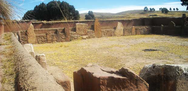
Chiripa archaeological site of Chiripa – Peace
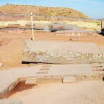
The archaeological site of Chiripa is a ceremonial site located in the Municipality of Taraco. From the place you have a wide view of the shores of Lake Titicaca.. It contains the oldest features with which the mathematical knowledge and architecture of the Andean world were formed.. It is part of the formative period of the region. When the towns were dispersed and disorganized, They began to group together in communities, demonstrating the need to incorporate technologies to master the production of ceramics and metallurgy..
This stage also represented a fundamental milestone in the interaction with other communities, since Chiripa began commercial exchange through the barter of agricultural products. This site is made up of an artificial mound of 50 a 60 meters in diameter by six meters in height, where an enclosure with several rectangular rooms is built, arranged around a semi-subterranean temple. In its surroundings there are some monoliths with zoomorphic representations that were part of the ceremonial architecture of the site.. Chiripa currently has a Regional Museum where some pieces recovered from the excavations carried out by the Taraco Archaeological Project are exhibited.. The temple was recently restored by the National Archeology Unit.
AUTONOMOUS DEPARTMENTAL GOVERNMENT OF LA PAZ
SECRETARY OF ECONOMIC DEVELOPMENT AND INDUSTRIAL TRANSFORMATION
DIRECTORATE OF CULTURES AND TOURISM
TOURISM UNIT
Similar items

October 14, 2025
July 18, 2015
June 17, 2016

November 24, 2015
October 16, 2025